
Wyoming Wild Horses — Red Desert, Adobe Town and the Great Divide
Wyoming is big country even before you start looking for Wyoming wild horses. Once you leave the interstates and oilfield traffic and roll into sage and buttes, the land opens up, and so does your sense of how far a mustang can travel between water and winter grass. This is checkerboard country, shared among BLM, private ranches and energy fields, so wild horses are only one part of a very busy landscape.
Across the state, BLM manages 14 wild horse herd management areas on almost 5 million acres of public land. The appropriate management level for those herds is set at just over 2,500 horses, although real world numbers often run higher, and gathers in places like the Red Desert Complex and Rock Springs District are frequent news.
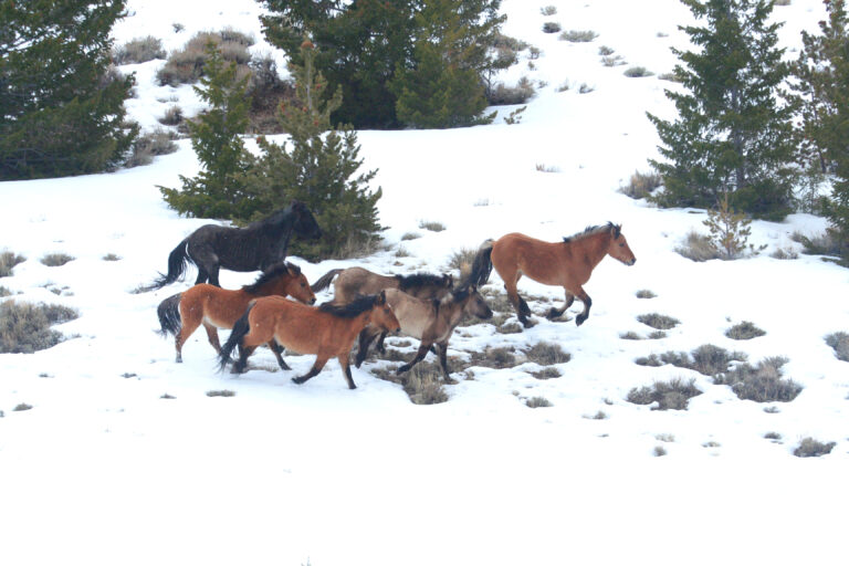
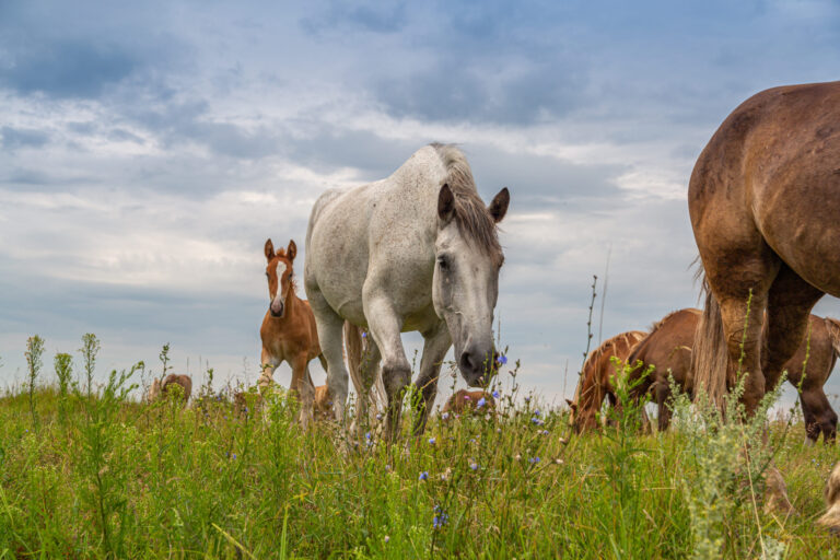
If you picture long lines of horses trotting across open sage with pronghorn in the distance, there is a good chance that image came from Wyoming. Adobe Town grays and roans, McCullough Peaks pintos, Green Mountain paints and bays and the bands on top of White Mountain all carry that big Western look that draws so many people to these ranges.
Wyoming is also a state where gathers, fertility control work and court fights over the checkerboard are part of the story. If you plan a trip, it is worth checking recent updates so you are not driving all day into a landscape that has just been gathered and gone quiet.
Why adopt Wyoming wild horses
There is no single “best” herd in Wyoming and there is no perfect horse. That said, many Wyoming bands carry a useful mix of ranch horse, cavalry remount and hardy saddle horse blood. You see a lot of sturdy bays, sorrels, browns and roans, some drafty and some quite leggy, with feet and lungs that grow up in wind, winter and long water gaps. If you want a forward, big walking trail partner or ranch style gelding, Wyoming is often where people start looking.
At a glance
- Signature look: Big frames, good bone, long walks and a lot of classic ranch colors – bays, sorrels, browns and roans – with pockets of chromey paints, palominos and buckskins in certain HMAs.
- Why people go: Wide open sage, badlands and high plateaus, bands that still move like they have somewhere to be, and a chance to see real working country as well as wild horses.
- Good first timers loop: Pilot Butte Wild Horse Scenic Tour above Rock Springs and Green River. It is a signed 24-mile loop across White Mountain where you can often spot horses from the road and still learn the feel of the country.
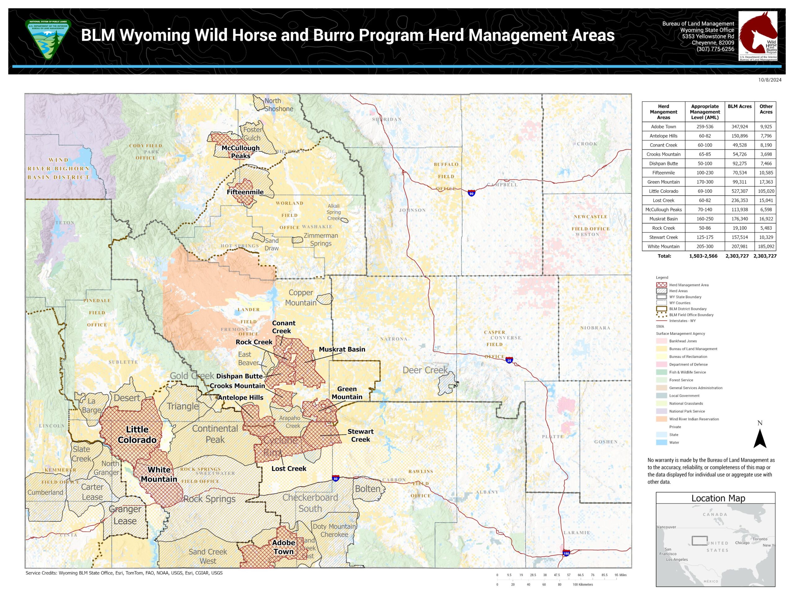
Map note: This map is a general overview, not a legal boundary map. BLM land use plans and court decisions can change HMA and HA status over time, especially in the checkerboard south. Always check the latest BLM maps and updates before planning travel.
Checkerboard South – Adobe Town, Salt Wells Creek and Great Divide Basin
Story
The Red Desert feels empty until it does not. One minute you are driving through low sage and dust devils. The next, a whole band steps over a ridgeline and strings out below the skyline. Adobe Town, Great Divide Basin, Salt Wells Creek and their neighbors spread across a huge piece of southern Wyoming, stitched together by the old railroad checkerboard and modern energy fields.
As of 2025, BLM land use plan changes for the Rock Springs and Rawlins field offices have reclassified the entire Salt Wells Creek and Great Divide Basin HMAs, and large portions of Adobe Town, as Herd Areas that are managed for zero wild horses. On paper that means the management target in those zones is no wild horses at all, and multi-year gathers are underway to remove the remaining bands. Lawsuits and appeals are still moving through the courts, so details may shift, but in practical terms many of these checkerboard miles may have very few or no horses on the ground by the time you travel.
This checkerboard south country has been at the center of some of the largest and most controversial gathers in Wyoming. Big multi-HMA roundups in 2018 and 2020 removed thousands of horses and turned national attention toward this landscape. What remains in many spots are smaller, more scattered bands that still know how to travel from water to winter feed without a fence to guide them.
In practical terms, all of this means you cannot rely on old trip reports or memories of “hundreds of horses everywhere” in this part of Wyoming. Places that once held large, visible bands may now feel very quiet, with only a few horses left in pockets of country that are still managed as HMAs. Before you drive deep into the checkerboard, it is worth checking the most recent BLM gather updates and land use decisions to see which areas still have active herds on the ground.
A few well known stars
If you have seen long telephoto shots of gray or roan bands trotting across low sage with dust in the air, there is a good chance you were looking at Adobe Town horses. Advocates and photographers have followed certain bands here for years and sometimes those horses carry their range names into adoption. Check current advocacy groups and recent BLM photos for who is still on the land before you go searching for one particular stallion.
What to look for
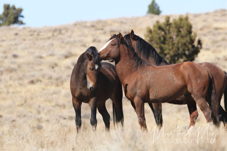
Adobe Town in particular is known for many grays and roans, along with bays and sorrels that look like classic ranch saddle horses. Great Divide Basin horses are a mixed saddle type, built to travel over flat, dry ground with little shelter from wind or storms. Salt Wells Creek has had a reputation for sorrels, palominos and even some curly coated horses.
Because the country is so large, you may go long stretches without seeing a single horse. When you do find them, it is often near water, on leeward slopes out of the worst of the wind or on the move between basins. Good glass and patience matter more here than raw miles.
Why adopt from the checkerboard south
If you see horses from Adobe Town, Salt Wells Creek or Great Divide Basin come up for adoption, you are often looking at horses that grew up in true open sage. They tend to have a big, efficient walk, good endurance and a practical, no-nonsense look. Many are not flashy, but they usually have the kind of feet and lungs that come from living far from shelter and learning to travel for every drink.
Visiting notes
- Most access roads are dirt or two-track. In wet weather they turn to slick gumbo, so a simple storm can turn a short outing into an all-day recovery.
- This is classic checkerboard country. Use current BLM maps and apps that show land ownership, and respect posted private land even if the fencelines are hard to follow.
- Fuel, food and cell signal are limited. Carry paper maps, extra water and enough fuel to backtrack if you need to turn around.
- Because BLM is currently managing Salt Wells Creek and Great Divide Basin, and much of Adobe Town, for zero wild horses, you may find very few or no horses in some parts of this region. Always check the latest BLM gather updates and land use decisions before you commit to a long drive into the checkerboard.
McCullough Peaks – Badlands and Colorful Bands near Cody
Story
McCullough Peaks sits out in the badlands east of Cody. The ridges and broken draws here feel like the edge of another world, but you can watch them from a paved highway and be back in town for supper. Many travelers fit this herd into a Yellowstone trip and come away talking about the horses as much as the park.
The Peaks are also at the center of recent debate over bait trapping and gathers. Local photographers and advocates have followed these horses for years, which means that many bands are well documented in photos and stories. That makes this a very personal herd for a lot of people and worth extra care from visitors.
A few well known stars
Calendars, prints and social media feeds are full of McCullough Peaks mustangs. Big paint stallions, dark mares with bright foals and bands that work the skyline have become minor celebrities thanks to years of patient field work by photographers. Some adopted Peaks horses carry those range names into their new lives, a reminder of the land they came from.
What to look for
Expect color and contrast. McCullough Peaks is known for eye-catching paints along with bays, sorrels, buckskins and the occasional gray. The horses use long ridges and badlands benches, often standing in clean light against layered rock. It is a place where you can practice reading ears and posture at a distance while you keep a safe buffer.
You will also see the rest of the community that uses this land. Pronghorn, deer, raptors and ravens all share the space. In winter, wind can be fierce and snow can drift deep in cuts and draws.
Why adopt from McCullough Peaks
If you like a horse with presence, the Peaks are a good place to look. Many McCullough Peaks horses have a nice balance of bone and refinement and a very photogenic way of carrying themselves. The long views and frequent visitors mean they grow up noticing vehicles without losing their caution, which can translate into thoughtful, people-aware riding partners after careful handling.
Visiting notes
- Some horses are visible from paved or good gravel roads. Long lenses let you stay in your vehicle and still read herd dynamics.
- Weather changes quickly. Summer storms and winter blizzards can both move in fast. Watch the sky and keep an exit plan in mind.
- Local photographers and advocacy groups often post recent sightings and road conditions. Checking their feeds before a trip can help you pick a productive time of day and season.
Green Mountain and the Lander Region – Timbered High Country
Story
In central Wyoming, Green Mountain rises above the sage and opens into a different kind of mustang country. Lodgepole forests, limber pine, aspen pockets and high meadows break up the usual sage and grass.
Around Lander, the North Lander Complex links several HMAs with open gates so horses can move to find forage and water. This is still wide open land, but it has more vertical relief and more timber than the southern Red Desert. You feel it in the way horses come and go between ridges and tree lines instead of endless flat basins.
A few well known stars
Green Mountain and the nearby complexes do not have as much social media attention as McCullough Peaks, but photographers who spend time here talk about stocky grays and paints at water holes and bands that ghost between trees on the upper slopes. A few of those horses have turned up in Wyoming-based adoption stories and clinics, often described as steady and “using” types rather than flashy photo stars.
What to look for
Expect variety. The Green Mountain HMA is known for a mix of colors, including bays, sorrels and a noticeable number of paints. Terrain ranges from timbered ridges and rocky outcrops to sage benches and riparian bottoms near springs and streams. Horses may be spread out in the shade during the heat of the day and more visible at first and last light.
Because several HMAs in this region are connected through open gates, bands may roam across boundaries that are marked on maps but not on the ground. Take this as permission to focus on terrain and sign rather than worrying too much about which HMA line you are inside.
Why adopt from Green Mountain and the Lander complexes
If you want a mountain trail horse, it makes sense to look at horses that grew up in real elevation and timber. Green Mountain and the nearby complexes produce solid, sure-footed horses that learn to travel on rock, deal with trees and brush and handle snow and wind on steep ground. Many have enough bone to carry a saddle and camping gear without looking heavy.
Visiting notes
- Roads can be rough and seasonal. Snow can linger on higher routes and thunderstorms can make clay and two-track roads very slick. Check in with local BLM field offices before heading into high country.
- Plan your fuel, maps and water before leaving main highways or Lander. There are long quiet stretches with little to no cell service.
- In summer, keep an eye on lightning and fire conditions. This is a place where storms can bring both beauty and real risk.
White Mountain and Little Colorado – Above the Interstate
Story
If you have ever driven Interstate 80 past Rock Springs and Green River and felt like the plateau above town was watching you, you were probably looking at White Mountain. The White Mountain HMA wraps across that high ground, and the Pilot Butte Wild Horse Scenic Loop gives you a way to leave the interstate and step into the horses’ world for a while.
Little Colorado lies nearby in rolling sage country. It is one of the easier HMAs for visitors who want to see horses without serious four wheel drive. Both areas share their space with energy fields, communication towers and the full tangle of modern life that hangs off a high plateau.
A few well known stars
White Mountain and Little Colorado do not have as many calendar cover horses as McCullough Peaks, but they show up often in road trip reports and BLM scenic loop promotions. Bands moving along the crest of White Mountain with Rock Springs far below are a familiar scene in travel stories and local newspaper pieces.
What to look for
On White Mountain, watch the skyline and the shallow draws that lead away from the main loop road. Horses may graze near the crest in early morning and late afternoon, then drop off toward water and sheltered spots as the day warms. Little Colorado tends to offer wide open sight lines across rolling hills, which makes horses easier to spot than in more broken country.
You will also see signs of how long horses have lived here. Stud piles along the road, well-worn trails contouring across slopes and old sign near water all tell the story even when the bands themselves are out of sight.
Why adopt from White Mountain and Little Colorado
Horses from these HMAs grow up with regular traffic, wind and a lot of human scent in the air. That does not make them tame, but it does mean they are used to vehicles, noise and change. Many have the kind of sturdy, medium to large frames and solid colors that blend easily into ranch, trail or pack work without feeling delicate.
Visiting notes
- The Pilot Butte Wild Horse Scenic Tour is a signed, mostly gravel loop that many people drive in a regular passenger car during dry months. High clearance and a weather eye are still smart choices.
- Over one third of Wyoming’s wild horses live in the Rock Springs District. Even if you do not see bands on the loop, you can visit the Rock Springs Wild Horse Holding Facility to see gathered horses up close.
- This is also checkerboard land. Stay on public routes, respect signs and remember that not every tempting two-track is open to casual visitors.
Ethics You Can Keep in Your Pocket
- Let the horses set the comfort bubble. If a head pops up, you are close enough.
- No calling, herding or feeding. You are there to observe, not to change the story.
- Use long lenses, stay on existing roads and step soft around water.
- In mud season, turning around is stewardship, not defeat.
Contribute and Credit
Have Wyoming photos or field notes to share? Comment or email with:
- Photographer name (as you want it displayed)
- Permission line: “used with permission”
- Optional: a one line caption or foal year or band details
More resources
More resources for trip planning, maps and current management:
- BLM Wyoming wild horse and burro page, with links to each HMA and gather updates.
- BLM Wyoming HMA brochure with a statewide map and basic herd notes.
- Travel Wyoming and local tourism sites for current road conditions, scenic byway information and seasonal suggestions.
- For current status of the checkerboard herds and any active gather plans, check the most recent wild horse updates for the Rock Springs and Rawlins field offices.
HMA vs. HA vs. WHT – what is the difference
- HMA stands for Herd Management Area. These are the official public lands where wild horses and burros are managed under the 1971 Wild Free Roaming Horses and Burros Act.
- HA stands for Herd Area. These are places where wild horses used the land in 1971 but that are not currently managed as official wild horse range. Some HAs still have horses but they are not being managed for long term herds.
- WHT means Wild Horse Territory and is managed by the United States Forest Service.
- Most Wyoming herds are classic BLM HMAs. The Pryor Mountain horses on the Montana and Wyoming line are a special case, managed as a Wild Horse Range that includes BLM land and overlaps a national recreation area.
- We update this page. Send factual corrections with a source such as a BLM or USFS page, a current map or a post from a local group, and we will log the change in the changelog.
Read the State Guides
These guides are coming online one by one. If a title doesn’t have a link yet, it just means I’m still writing it—check back soon.
Last checked: November 30, 2025.

One Comment